Topic Actions

Topic Search

Who is online

Users browsing this forum: No registered users and 26 guests

My little project - a maptool for Honorverse

Join us in talking discussing all things Honor, including (but not limited to) tactics, favorite characters, and book discussions.
My little project - a maptool for Honorverse
Post by Joat42   » Thu Aug 06, 2015 6:33 pm

Joat42
Admiral

Posts: 2146
Joined: Tue Apr 16, 2013 7:01 am
Location: Sweden

One of my pet-peeves has been the problems trying to find out where a planet is located when mentioned in the books. Looking at the maps in the dead tree editions isn't that helpful and there are numerous incarnations of the universe map spread out over all the books. There are some fairly good maps online but they aren't really searchable.

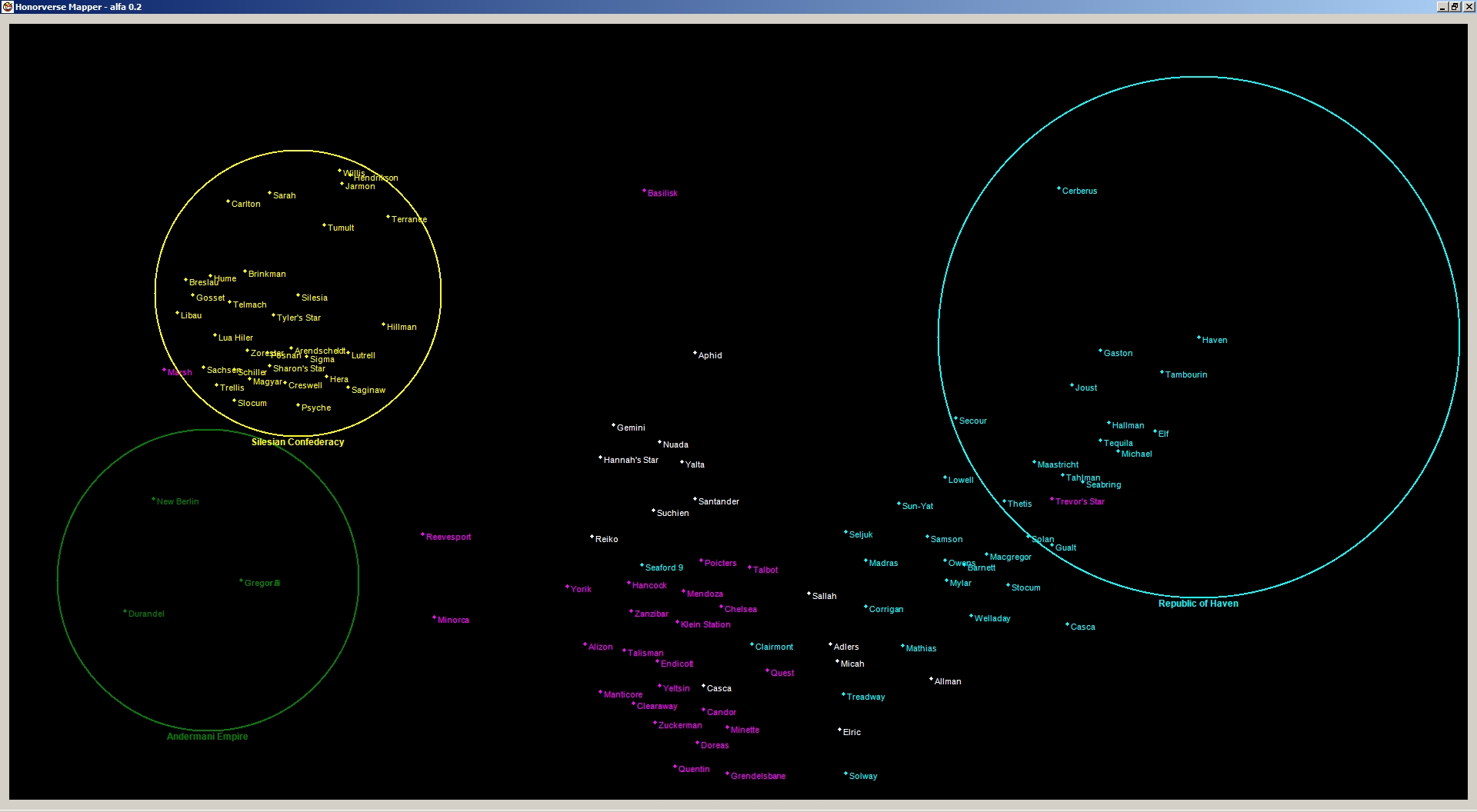
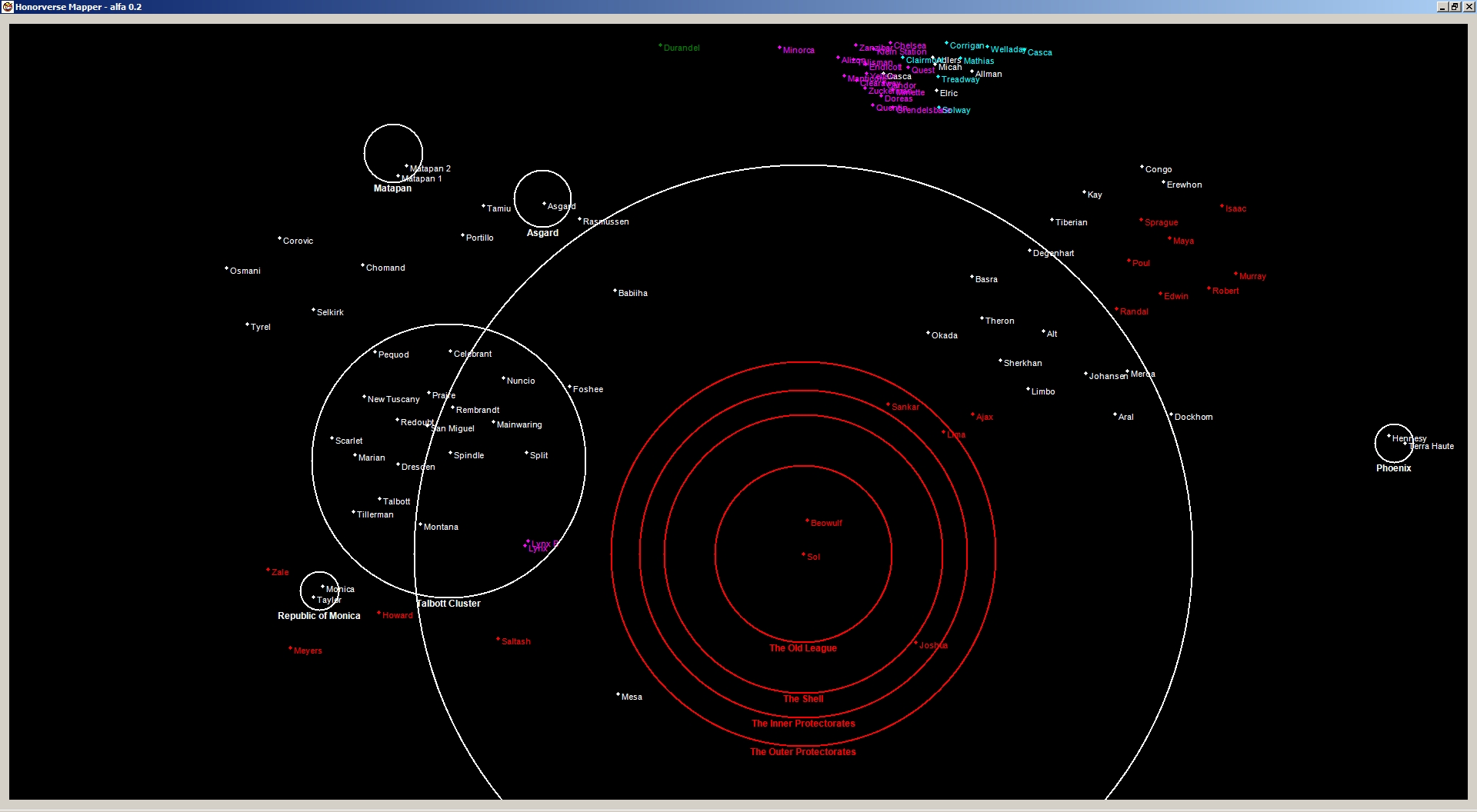
So I put together a smallish database for testing purposes which I then used to generate a map of the universe:

click to embiggen
Image


I'm sure it looks a bit familiar albeit lacking in detail.

Then plan is to make it to a kind of companion which you search and reference everything relevant to the universe map.

The following features is my wish-list right now:
  • More systems, especially from the Solarian League since I couldn't find any info.
  • Expanded data about starsystems, ie. planetary bodies, hyperlimits, wormholes, resonance zones etc etc.
  • Naval bases (may belong to the point above)
  • Wormhole connections.
  • Gravwaves.
  • Distance measurement tool.
  • Political overlays, ie. spheres of influence.
  • Historical data, ie. you select a year and the map changes to how it looked then (mostly possession of starsystems).
  • Selectable overlays for which data you want to see.
  • Possibility to add, edit and expand the database, ie. submit changes, receive updates.
  • Create and export images of the whole map or parts in a variety of formats.
  • .. and a bunch of other things that probably will be selfevident as the project progresses.

Currently the project is just me testing things out with C# on Windows but I'm looking into how to proceed so that the application will be multi-platform (currently investigating SFML which probably means support for Windows, Linux, Mac, Android & iPhone).

Now, don't expect me to deliver something polished in short time - I'm a bit erratic when it comes to my personal projects which is mostly due to my work schedule.

And now to a question, does anyone have a dataset with planets? Name, polity, location etc. Currently I'm using what has been gleaned from published maps and the maps on Honorverse Glossary, but the distances are a bit "funky" because of this.

---
Jack of all trades and destructive tinkerer.


Anyone who have simple solutions for complex problems is a fool.
Top
Re: My little project - a maptool for Honorverse
Post by Armed Neo-Bob   » Thu Aug 06, 2015 6:38 pm

Armed Neo-Bob
Captain of the List

Posts: 532
Joined: Tue Jun 24, 2014 7:11 pm

Joat42 wrote:
And now to a question, does anyone have a dataset with planets? Name, polity, location etc. Currently I'm using what has been gleaned from published maps and the maps on Honorverse Glossary, but the distances are a bit "funky" because of this.


Not to mention, the vertical distances don't play too well with the maps. There was an official BuNine effort, once, but it wasn't finished that I ever heard.

Rob
Top
Re: My little project - a maptool for Honorverse
Post by SWM   » Thu Aug 06, 2015 8:39 pm

SWM
Fleet Admiral

Posts: 5928
Joined: Mon Jan 11, 2010 4:00 pm
Location: U.S. east coast

I made a composite map of the Honorverse, combining all existing maps together, overlaying onto the Jayne's maps as a base. I discovered that over 90% of the stars on the other maps appeared on the Jayne's maps--including both the Maya sector and the Talbott Cluster, even though Jaynes was published many years before those books. The composite map is available at http://www.gotshifted.com/honorverseglossary/MAPS.html, along with Sawa's composite map. If I recall correctly, the scale of the map is 1 light-year per pixel, but I'll have to check.

I have a spreadsheet contains every mention of a distance (in time or space) between star systems that appears in the text. A second page of the sheet lists the coordinates of every star mentioned on the first sheet, along with coordinates measured on my composite map. A couple columns in the first page compare the distance measured on my composite map to the distances implied by the text. The spreadsheet is dynamic, incorporating formulas and VLOOKUPs to calculate everything. With the exception of the Talbott Cluster, distances are not that bad. For the most part, David had been measuring distances on flat sheets of paper up until Shadow of Saganami. Starting with the Talbott Cluster, his distances do not match the maps at all.

The only map that was not incorporated into the composite map is the so-called "illegible map" which David released to the forum, depicting a large area around the Talbott Cluster and Mesa. That map was David's first experiment with online mapping software, and it cannot even be matched to the map in Shadow of Saganami.

I don't know whether any of this work would be of interest to you. :D
--------------------------------------------
Librarian: The Original Search Engine
Top
Re: My little project - a maptool for Honorverse
Post by SWM   » Thu Aug 06, 2015 8:51 pm

SWM
Fleet Admiral

Posts: 5928
Joined: Mon Jan 11, 2010 4:00 pm
Location: U.S. east coast

Oh, and just to be clear, most of the stuff on your wish list is completely unknown, as I'm sure you know. :)

All of wormholes we can plot are marked on my composite map. There are a half-dozen other wormholes mentioned, but we do not know where either end of any of those wormholes are located on the map. We could guess approximately where Mesa and Visigoth are, but not well enough to plot them on the map.

The political boundaries that we know of are on my composite map. The boundaries are as of the beginning of the war, with the exception of the Talbott Cluster.

We have only a few clues about the locations of grav waves, and in most cases we have only single points--for instance, we know there is a grav wave somewhere close to Grayson, another close to Basilisk, and a few specific stars are noted as being in grav waves. But that's not really enough to plot grav waves.

But you know all this, I'm sure.
--------------------------------------------
Librarian: The Original Search Engine
Top
Re: My little project - a maptool for Honorverse
Post by n7axw   » Thu Aug 06, 2015 10:28 pm

n7axw
Fleet Admiral

Posts: 5997
Joined: Wed Jan 22, 2014 8:54 pm
Location: Viborg, SD

SWM wrote:Oh, and just to be clear, most of the stuff on your wish list is completely unknown, as I'm sure you know. :)

All of wormholes we can plot are marked on my composite map. There are a half-dozen other wormholes mentioned, but we do not know where either end of any of those wormholes are located on the map. We could guess approximately where Mesa and Visigoth are, but not well enough to plot them on the map.

The political boundaries that we know of are on my composite map. The boundaries are as of the beginning of the war, with the exception of the Talbott Cluster.

We have only a few clues about the locations of grav waves, and in most cases we have only single points--for instance, we know there is a grav wave somewhere close to Grayson, another close to Basilisk, and a few specific stars are noted as being in grav waves. But that's not really enough to plot grav waves.

But you know all this, I'm sure.


Hi SWM,

I found that impressive. Just glancing at where Talbott is makes it obvious why the SLN found Manticore's presense there such a royal pain in the arse...

I just glanced at it with an android. I'll have to try with a full sized computer screen tomorrow. Thanks for your good effort.

Don
When any group seeks political power in God's name, both religion and politics are instantly corrupted.
Top
Excellent Information And Thank You ...
Post by HB of CJ   » Thu Aug 06, 2015 11:16 pm

HB of CJ
Captain of the List

Posts: 707
Joined: Thu Jul 11, 2013 10:46 pm
Location: 43N, 123W Kinda

You all went to a great deal of work and thank you.
Top
Re: My little project - a maptool for Honorverse
Post by Joat42   » Fri Aug 07, 2015 8:00 pm

Joat42
Admiral

Posts: 2146
Joined: Tue Apr 16, 2013 7:01 am
Location: Sweden

Progress update:
  • Added basic support for clusters/areas and spheres of influence.
  • Basic zoom functionality
  • Name of star-systems (looks cluttered where there are many planets).

Screenshots:
click to embiggen
Image


click to embiggen
Image


Next step is add support for wormhole connections and after that I want to set up datasets with normalized data so I can scale imported system locations automatically by matching known systems against imported ones. Will make it trivial to import almost any location data regardless which scale they have used - as long as I can match at least 2 planets.

Cheers!

---
Jack of all trades and destructive tinkerer.


Anyone who have simple solutions for complex problems is a fool.
Top
Re: My little project - a maptool for Honorverse
Post by Tenshinai   » Fri Aug 07, 2015 8:37 pm

Tenshinai
Admiral

Posts: 2893
Joined: Tue Nov 02, 2010 8:34 pm
Location: Sweden

Good work.
Top
Re: My little project - a maptool for Honorverse
Post by Joat42   » Fri Aug 07, 2015 9:17 pm

Joat42
Admiral

Posts: 2146
Joined: Tue Apr 16, 2013 7:01 am
Location: Sweden

I've noticed that there are several inconsistencies for some star-systems between different maps.

For example, Mesa appears in 2 different places - southwest ~310ly of Sol or south ~150 ly of Spindle (ie. south of the Talbott Cluster).

Joshua is placed at the edge of the Shell SE of Sol on most maps but JRMN has it on the edge of the Shell NE of Sol.

I just wished I had a complete dataset of the systems from someone in the know, transposing locations from books and pictures are kind of tedious. :roll:

---
Jack of all trades and destructive tinkerer.


Anyone who have simple solutions for complex problems is a fool.
Top
Re: My little project - a maptool for Honorverse
Post by SWM   » Fri Aug 07, 2015 11:12 pm

SWM
Fleet Admiral

Posts: 5928
Joined: Mon Jan 11, 2010 4:00 pm
Location: U.S. east coast

Joat42 wrote:I've noticed that there are several inconsistencies for some star-systems between different maps.

For example, Mesa appears in 2 different places - southwest ~310ly of Sol or south ~150 ly of Spindle (ie. south of the Talbott Cluster).

Joshua is placed at the edge of the Shell SE of Sol on most maps but JRMN has it on the edge of the Shell NE of Sol.

I just wished I had a complete dataset of the systems from someone in the know, transposing locations from books and pictures are kind of tedious. :roll:

The position of Joshua has indeed shifted on various maps. It has been depicted NE of Sol, SE of Sol, and WSW of Sol. Tom Pope has confirmed that it is supposed to be WSW of Sol.

For the official location of Joshua, you might look at the map on the title page of the Tales of Honor comics. The map is officially approved, and Tom Pope has said that is the correct location of Joshua/Sasebo.

As for Mesa, I see that you are using Sawa's composite map. I pointed out to him some significant discrepancies in the Talbott Cluster on his map, including Mesa. Sawa based the position of Mesa and the Talbott Cluster on the somewhat vague map David made depicting the shells of the Solarian League. It is my belief that the position of Mesa on that map is nowhere near correct, and the position and orientation of the Talbott Cluster does not match other material. Sawa agreed that there were discrepancies, but it was all he had to work with. We agreed to disagree on his use of that map as his basis. :)
--------------------------------------------
Librarian: The Original Search Engine
Top

Return to Honorverse